Ecuador Volcanoes - A Climbing Trip Report
By Scott Schumann, AAI Guide

The Cayambe hut with the Hermosa glacier pouring in slow motion down the mountain's West Face.
Editor's note: Climbing in Ecuador combines travel amid great cultural beauty with high quality ascents on big-scale glacier routes. AAI pioneered guiding there with its first trips more than 35 years ago and has been guiding in Ecuador ever since. The Institute offers expeditions to all the major volcanoes, including the popular Cotopaxi climb and Chimborazo extension, as well as less-traveled Antisana and Illiniza and rarely-climbed gems like El Altar. Joining a recent trip to climb Ecuador volcanoes was AAI guide Scott Schumann, and he has written the following account of his experiences.
Quito, Otovalo, and Warmup Climbs
We arrived in Quito, Ecuador's capital city, and after an easy customs check, found our way to the Hotel Quito. The hotel sits perched on a hill overlooking the modern city to the south, and to the east we had photogenic views of Antisana from our hotel room. All told there were 4 of us on the trip: Paul Houmann (Greenville, NC), Bill Roberts (Dallas), Jay Hack, one of AAI's senior guides, and myself.
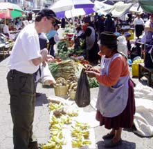
Paul buying some fresh bananas from a Quechua woman at the Otavalo market.
The following day we all met for breakfast at the hotel buffet and had our first taste of the fresh fruit juices which were to be commonplace at most restaurants we visited. Imagine having every type of exotic fruit you can imagine (along with others you've never heard of) freshly squeezed and waiting for you each morning. Mountaineering stories typically wax poetic on the themes of hardship and difficult conditions, but we soon would find Ecuador to be at the other end of the spectrum from the "food rationed epics" you might read about in the magazines.

Paul on the exact line of the Equator.
After breakfast, we traveled north and crossed the exact line of the Equator. Of course we stopped for the compulsory "I'm on the Equator" photographs and looked at a few of the local crafts. The US dollar is the common currency of Ecuador after an economic crisis in the 90's left Ecuador's Sucre valued in the 10's of thousands to the dollar. Strangely, we purchase goods and services here with the same money we were using to buy milkshakes over 4000 miles away.
We spent the rest of our first full day in Ecuador acclimatizing at 10,000 feet while walking around the famous Otavalo market. Exploring the market and interacting with the Otavalenos was truly a rewarding cultural experience. The indigenous Quechua people and their crafts reflected of the beauty of the Andean geography.
The hardiness of this culture was evident in their crafts made of native sandalwood and the warmth of the people seemed to be present in their colorful woven blankets. The native language here is Quechua, with Spanish the second language of the rural citizenry. This made communicating with the locals fairly comfortable for even the novice Spanish speakers among us because the Quechua tend to speak Spanish slowly with careful pronunciation.
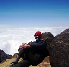
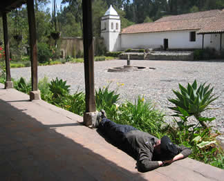
The author relaxing above the clouds on Pasachoa's summit.
After marveling at the "grocery" section of the market (which included guinea pigs, a 200lb hanging pig, and vegetables piled 2 feet high on the sidewalk), we opted for a traditional lunch and walked over the hillside to Lago San Pablo and a restaurant on the shore of the lake across from Imbaburra (15,026 ft).
Over the course of the next 3 days we progressively acclimatized on the peaks surrounding Quito. Our first day-hike on Cerro Pasochoa (13,776 ft.) was a lot of fun. We hiked up through a forest preserved by a local environmental group and enjoyed a fantastic cloud display below us at 12,500 feet.
On our second acclimatization hike, two of us surpassed our personal high altitude records when we reached the summit of Guagua Pichincha at 15,728 feet. Unfortunately, our summit experience was dampened by a search being conducted for a local man who had come out to hike the mountain by himself and had not been seen for several days. We kept an eye out for something that might offer a clue during our descent, but we never saw anything.
This outstanding trip typically includes an acclimatization trek, a skills introduction and/or refresher, and ascents of Cayambe, Cotopaxi, and either Chimborazo or Illiniza.
- Length: 10-15 days
- Location: Ecuadorian Andes
- Cost: $2370-$3660
Click to learn about our Cotopaxi climb.
We eventually moved out of Quito and drove north up the central valley to the lower flanks of Cayambe where we stayed in a beautiful old hacienda. One of the oldest in Ecuador, it was originally home to an ancient people, and the grounds are filled with artifacts discovered over the years from archeological digs. Since the building of the hacienda in 1580 visitors on the guest list have included several Popes, national presidents, and aspiring climbers such as ourselves.
We each were getting a bit anxious to climb. Although we were enjoying the sopa de quinoa (a typical Ecuadorian soup), rich Columbian coffees, and fresh tropical fruits, we were all feeling quite acclimated and ready to venture higher.
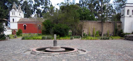
The central courtyard at our hacienda near Antisana.
Cayambe (18,996 ft.)
After a night at the hacienda, we moved up to the Cayambe hut and reviewed skills for our climb. Each of us were dealing quite well with the altitude but a slight headache was right around the corner if we exerted ourselves too much or too quickly.
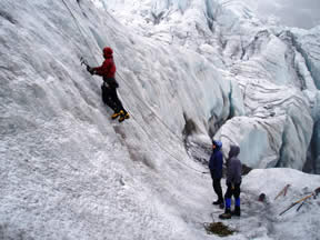
Jay introduces two tool ice climbing technique.
The next morning we moved out onto the lowest flanks of the glacier where Jay reviewed crampon and ice axe techniques. We practiced on gentle ground and then set up a top rope to practice some ice climbing technique on steeper terrain. Everyone picked up the tricks of the trade quickly: well aimed strikes, moderately wide stances, and hips in! Later on, we moved inside the hut and brewed up hot drinks, then reviewed our crevasse rescue and prusik systems.
Alpine start 12:30 a.m. Now this was climbing: waking up well before dawn with a cold wind blowing and wanting to stay in your sleeping bag until some else's alarm went off so you can savor those last few minutes of sleep before you roust yourself. We each prepared our summit packs and met for breakfast a bit groggy but very motivated.
We set out by 1:30 a.m. and were soon into some enjoyable 3rd and 4th class scrambling which included a short belay up a couple 5.0 moves. The top of this section popped us out on the "Sandy Bench" with a cold wind blowing at 16,000 feet.
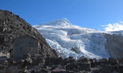
The Cayambe hut with the Hermosa glacier pouring down the mountain's West Face.
We reached the snow and ice of the Hermosa Glacier and roped up for glacier travel. I think we were all getting pretty excited as the sun came up and light was cast on our route. We now moved a bit slower due to the altitude and heavily crevassed nature of the glacier. Eventually we reached Punta Jarrin, a huge rock bugaboo jutting up out of the glacier at about 17,000 feet, and it was time to assess our progress.
We were moving well but a bit too slowly to make the summit early enough in the day to be safe. We discussed continuing on until a specified turn around time well below the summit or chalking up the up climb thus far to good acclimatization and returning back to the hut. Collectively, we chose the latter.
Cotopaxi (19,347 ft.)
After a rest day back at the hacienda (and enjoying filet mignon at a fraction of what you would expect to pay back home - 4 dollars!), we traveled south to Cotopaxi National Park. The Jose Ribas Hut perched below the glacier on Cotopaxi is in an exciting position from which to view the mountain and our route.
We were well rested and feeling better at altitude at that point than any previous point in the trip. Again we began with an alpine start at 12:30 a.m. and were the first climbing team out of the hut around 1:30 a.m.
We flowed up the glacier like we were tied to a helium balloon. We did not climb fast but rather at an intentionally moderate pace, making each step feel no harder than the last. This season's route took us to the right of the Yanasancha, an enormous black rock band which is a discernable feature on the mountain even from the central valley hundreds of miles away. Once we reached the crevasse next to the Yanashancha, we rested before the crux of the route.
Our route meandered over snow bridges, around sections of neve penitentes, and crossed an interesting thermal section at about 18,750 feet. where heat from the volcano's active core had melted the ice down to the basalt and andesite layers on the mountain's surface. The thermal area faded into the final steep section through rime-covered slopes of snow and ice.
We reached the top of the climb via a steep ramp that eventually led to nearly flat slopes. It was exciting to finally be on the 19,253 foot summit and a bonus to feel really good. We stopped and congratulated each other on reaching the "half way point" because we still had a long descent back to the hut. We took pictures through breaks in the cloud cover and then headed down.
We returned from our climb to many congratulations and handshakes from our vehicle driver Jugo who was eagerly awaiting our return.
Hacienda La Cienega, Latacunga, and Quilotoa Crater
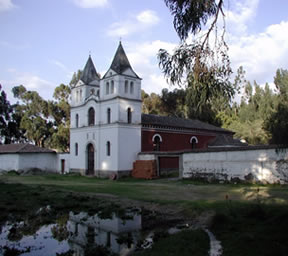
Jugo took us to Hacienda La Cienega on the floor of the central valley. There we spent the night and enjoyed recovering from our climb in the beautiful gardens of the hacienda and at the dining table, continuing our sampling of local food.
That night we reviewed the details of our successful climb and discussed conditions for our next objective. We opted for a rock climbing route on Illiniza Norte (16,817 ft.), but first we earned a rest day.
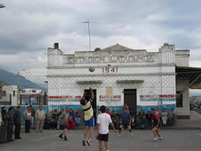
We went on a day hike in the Quilotoa Crater near Pujili. We drove through Latacunga, the capital of Cotopaxi Province, where we had an opportunity to watch a developing cultural phenomenon in Ecuador: equivolley, Ecuador's own version of 3 on 3 volleyball, with loosely interpreted rules for keeping the ball in play and almost exclusively played with a soccer ball.
Jugo illustrated his growing command of the English language as he succinctly explained to us that it is becoming more common to see kids and adults playing equivolley than soccer on playgrounds across the country.
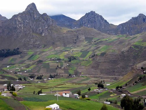
Driving up out of the central valley towards Pujili was an experience in itself. The Pan-American highway runs between the eastern and western cordillera, making the views out each side of the car windows equally rewarding. When we turned off the highway, we were amazed at the beauty and simplicity of the thatch homes in which the campesinos live. The drive to Quilotoa Crater took us past the Nido De Condores (condors nest) where we saw condors circling the high buttresses above the valley.
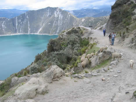
We reached Quilotoa and enjoyed a leisurely walk down to the blue crater lake below. It was a great day to stroll off some of the stiffness from our summit climb a day earlier.
Illiniza Norte (16,817 ft.)
The following day our approach to the Illiniza hut involved hiking up a braided stream through grasslands and smaller forests until it opened up into the alpine zone free of any vegetation aside from heather.
The route climbed steeply up from the Illiniza hut situated at the col between Illiniza Norte and Illiniza Sur. Norte is composed of a very high quality volcanic rock. The amazing friction reminded Jay and me of the west ridge of North Twin, a classic route back home in northwest Washington. We followed up a narrow exposed ridge on Norte's south east side with sweeping exposure to our left and right. It was great position! Eventually our route wrapped around to the north into a clean gully system. Temperatures were cool, and a little bit of rime ice had formed in some of the deeper chasms of the gully.
Thankfully, we moved through the shaded fourth class rock quickly and found ourselves in the sun on the summit enjoying close-up views of Illiniza Sur's north face. We soaked up our last summit in Ecuador for the trip and enjoyed our lunch before descending back to the vehicle by nightfall.
Baños: Hot Springs and Mangoes
With our last days of the trip we traveled down to the oxygen-rich town of Banos. Situated on the rim of the Amazon basin, the location of Banos provided plenty of activities to fill our remaining time in the country.
We soaked in the natural hot springs pouring from the mountain in the southern part of town, drove down into the Amazon jungle for birding and a day hike, and then took a short drive up above the town to view the light show at night displayed by the erupting lava from Tungurahua volcano. I remembered hearing that AAI used to guide Tungarahua as part of one of its itineraries back in the late seventies and early eighties.
The Nido de Condores area is great for hiking and scrambling, and we saw quite a few condors soaring here.
Our time in Ecuador was coming to a close, but our adventures were sure to stay with us with us like the lingering taste of sweet mangoes. On our last day, we each purchased colorful woven blankets and scrambled for a few final photos of the Andes to take home with the hope of conveying the beauty of this place to our friends and families. Besides enjoying forming some new friendships (and really enjoying the food), the trip will remain a great memory for me for two reasons: first, it was a great trip on which I was able to see how well I function at altitude; and second, it was an enriching experience that exposed me to simple and beautiful ways of rural life that I had never previously seen. While I came for the climbing and enjoyed it tremendously, these other experiences will make it a memory that I will feast on for many years.
Click on the links to view all our programs on Ecuador's Volcanoes or all our programs in South America. Give us a call at the AAI office for more details on the climbing or to discuss joining this or one of our other Andean adventures. (360) 671-1505.
Program Finder