Success in Sichuan: Second Ascent of Reddomaine
An AAI Team Makes the Second Ascent of China's 20,050-foot Reddomaine
by Aidan Loehr
AAI Instructor and Guide
Mountain climber or not, most everyone has heard of the Himalaya, home to the tallest mountains in the world. What many don't know, however, is that just east of the Himalaya, at the convergence of eastern Tibet and the Sichuan Province of southwest China, stand some of the world's tallest remaining unclimbed mountains. Only recently opened by the Chinese government to outside visitors, many of these ranges, consisting of young, sharply etched peaks with beautiful rock faces and pristine glaciers, still await their first exploration.
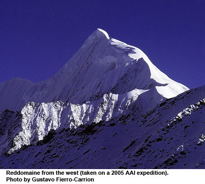
One such range is the Daxue Shan Range (a sub-range of the Hengduanshan Range), and it is just starting to see the traffic of foreign climbers and Chinese trekkers. This range includes several unclimbed 16,000- to 19,000-foot peaks, as well as China's highest peak outside the Himalaya, Minya Konka (24,790', 7556m). This fall, an AAI climbing team led by guide Aidan Loehr trekked the entire length of the Minya Konka Range, stopping along the way to make the second ascent of a striking mountain called Reddomaine. At 20,050 feet, Reddomaine (Tibetan for "sharpening stone") was first climbed in 1999 by a Japanese team via the elegant West Ridge. The AAI team succeeded in the second ascent via the same route on October 4, 2006.
Following are Aidan's journal entries as he and climbers Bill, a 68 year-old investment counselor from Toronto, and Colin, a 64 year-old engineer from North Augusta, ON, made the journey from Chengdu to the remote mountains of the Minya Konka Range and to the summit of Reddomaine.
*All photos by Bill and Colin, unless otherwise noted.

September 26, 2006 - Day 1
After returning from a personal climbing trip to far western Sichuan province, Andy Bourne (AAI Guide and Program Coordinator) and I returned to Chengdu to prepare to guide the upcoming expedition to Reddomaine. After completing our errands and food shopping, which is an adventure in an of itself similar to visiting the zoo, we waited at our hotel with Xiaomei (our local guide and interpreter) for Bill and Colin to arrive. After some minor baggage trouble, the two finally made it to the hotel by mid-afternoon. A couple of beers and a good dinner later, everyone was ready to call it quits for the night. So off to bed everyone went.
 September 27, 2006 - Day 2
In the morning we were joined by Xiaomei and Jing Jing (our Base-Camp-Manager-to-be), and Bill, Colin, and I climbed into two Beijing Jeeps (China's answer to Range Rovers) bound for Kangding.
Seven hours later we arrived in Kanding, at 9,000 feet, the perfect first step in our acclimatization schedule. Kangding is a border town where Tibetan and Chinese culture overlap. It is not uncommon to see Chinese tourist, dressed in western style, mingling with Tibetan Khampa men and women dressed up in their traditional finery. The Tibetans seem very fond of bright colors both in clothing and architecture. Women commonly wear red ribbons and large colorful beads woven into their hair and long wool dresses. Men wear a robe-type wool jacket with oversized sleeves and large decorative knives conspicuously worn on the belt. Tall fur hats, gold teeth and long braided hair are common in both men and women.
After checking into our very posh hotel we all headed out into town. Breezing past the pink light district (yes it is what you think - it is carefully disguised as barber shops) we found numerous little shops peddling all sorts of Tibetan wares. I couldn't resist a silver embossed knife with a pair of chopsticks stored in the sheath. Very practical. I am sure to find lots of uses for it back home.
We had a very elaborate dinner with all the dishes picked out beforehand by Jing Jing. We were even serenaded by one of the waitresses. She sang what is evidently a classic Kangding love song. Xiaomei did her best to translate it for us.
September 28, 2006 - Day 3

We left Kangding at 9:30 this morning after receiving a blessing at the Buddhist monastery and making a last ditch shopping effort for umbrellas! Hopefully, if we have them with us, they will not be necessary! We then drove 20 minutes to the small Tibetan town of Laoyuling, where we met up with Dorje, the man who will be providing the horses for the next phase of the journey. We are staying in Dorje's guesthouse tonight - a little more Spartan than the hotel. I think that we have seen our last shower for the next couple of weeks.
After stashing gear at the guesthouse, we left for an acclimatization hike. After about 13 miles and 3000 feet of elevation gain, we were at the pass near the mountain of Lamoshe. Still sitting in the morning mist, we were optimistic that we could hike above the clouds and gain an unobstructed view of the surrounding mountains. At about 14,500 feet we topped out above the clouds into a bluebird day! All the mountains in the Minya Konka Range were laid bare before us, each peak topped with its own crown of cumulus clouds. Xiaomei told us the story of the range. Minya Konka is the King of the range and he is surrounded by 14 lesser peaks that represent his generals. Not all the generals were clear from our seats to the north, but it was still an impressive sight.
We had a little snack at 14,700 feet. Bill had higher ambitions so he and I went on up to 15,100 feet. Not bad for the second day at altitude.
When we returned to the guesthouse Bill, Colin, and I took a walk into Laoyuling. We drew a small crowd of school kids, and we tried with limited success to communicate with them. Very amusing. They were especially taken with Bill. Colin and I almost had to rescue him from a kidnapping attempt. We also passed a newly butchered Yak. The middle of the road seems to double as the local slaughter house.
Back again at the guesthouse, we found a large crowd on the first floor. The Chinese national holiday was upon us and Chinese trekkers were gathering for the hike to the Gonga Monastery (the 600 year old monastery at the base of Minya Konka). Turns out the trekkers were planning to do the same hike that we were, minus climbing a 20,000-foot mountain! In theory they are supposed to move faster than us. We shall see.


September 29, 2006 - Day 4
We started hiking at 8:50am up the road to the trailhead. Laoyuling is at roughly 11,000 feet, and it's about an eight-mile hike to Camp I at 13,300 feet. In all, it is a three day hike to base camp. It could be done faster, but with a 16,000-foot pass to cross, you need the days to acclimate.
After threatening to rain all day, it finally started shortly after the horsemen arrived at camp with the tents. Good timing I must say.


September 30, 2006 - Day 5
Short hike today - three hours to Camp II, which is at 14,300 feet and in a wide valley that the Yak herders use as a summer base. With the north face of Reddomaine at the south end and Jiaza and Little Konka (as the locals call it for its resemblance of the highest peak) dominating the eastern skyline, it is a pretty cool place to spend the night.
Due to the national holiday coinciding with our trek, the valley is also occupied by some Chinese trekkers. We were using one of the summer yak herder tents as a cook tent, and as it started to rain, many of the trekkers found their way inside. The tent was maybe 20 feet by 20 feet, and at one point Bill and I took a head count and there were 25 - 30 people packed inside. Very cozy.


October 1, 2006 - Day 6
Woke to falling snow. It was not sticking, but it did reduce visibility to only 200 feet or so. The cook tent, which usually functioned as a mobile barn, was still packed with trekkers escaping the weather.
We were out of camp at 9am headed for the 16,000-foot Riuchi pass. After hiking for an hour or so in very poor visibility, the route finding was starting to become a challenge. Bill had no doubt as to where to go, and just as the compass was coming out to ascertain our whereabouts, a break in the clouds revealed prayer flags marking the pass. Bill was right on!
As we reached the pass, the weather cleared up even more and we could see the trail below us packed with trekkers, horsemen, and horses staggering up to a high pass. It made me think of the Chilkoot pass during the Alaskan gold rush.
After watching the show for bit, we were finally shooed away from our lofty perch by the arrival of the string of horses that needed to pass through. So we descended the other side of the pass towards Camp III at 14,500 feet, which will serve as our base camp the upcoming summit attempt on Reddomaine.
After setting up camp, I decided to carry a load up to High Camp with the rest of the daylight. I was scouting for evidence of the high camp at 16,400 feet that was built by last year's team. After a two-hour hike I finally found the promised markers: Three beers from last year carefully propped up on a rock shelf. Caching my gear at the site, I took a moment to enjoy the view. The valley below had fogged in while I climbed. Base Camp was obscured to the west, and over the opposite ridge the views opened up to reveal the endless plains and ridges that create the eastern edge of the roof of the world - the great Tibetan Plateau.
Back at camp, the horsemen had all headed for home. Even the Chinese trekking groups had finally passed through, leaving just Jing Jing, Xiaomei, Bill, Colin, and me
October 2, 2006 Day - 7
Woke up to five inches of new, wet snow on the ground. We delayed our planned trip to High Camp until the snow stopped falling. Finally, at noon, Bill, Colin, and I headed up to high camp with another load of gear.
Carrying loads served as a good indicator of our fitness and acclimatization. We made good time on the carries - a very respectable three hours and ten minutes - and everything seemed to be on track. This bodes well for summit day. Leaving all the climbing gear and food we would for the five days we were going to give ourselves for the summit attempt, we headed back to the comforts of Base Camp and dinner.
Just above Camp III lies the entrance gully for Reddomaine, whetting our appetite for the climb above.
October 3, 2006 - Day 8
The day started off looking good. We left Jing Jing and Xiaomei at 10:50am and began our move to High Camp. Thanks to the work we put in yesterday, we had fairly moderate packs (40 pounds or so). We made high camp in three hours with darkening skies on the horizon. We set up our tents on the small, but nice, sites left from last year. Bill worked hard to improve the platforms, as he urged Colin "for the good of mankind." The work for humanity lasted until the snow started. Or maybe it was the thunder and lighting that dampened our enthusiasm for good works.


A brief discussion of weather in the range. One word describes it - unpredictable. As near as I can tell, there is no good way to predict what is going to happen from one hour to the next. In general, there seems to be a clearing period at midday. Other then that it's something of a crapshoot. My strategy is to pick a departure time and stick to the plan unless the weather starts to get extremely bad.
At 4:30pm the weather cleared up, and with great effort I dragged myself away from the comfort of my sleeping bag and set out on a little recon mission up to the gully. The snow line was at about 17,000 feet. The snow was firmer than I thought it might be and was ankle to mid-shin deep. Not bad for kicking good steps! I reached the top of the gully at about 17,700 feet and racing the dark I arrived back at camp around 7:30pm.
We savored the three beers that had waited for us since the year before, then headed to sleep.
October 4, 2006 - Day 9
Today all three of us headed upwards for a little acclimatization. It was about three hours or so to the top of the snow-filled gully, leading to the ridge proper. We spent some time there for a snack and headed down in time to miss yet another afternoon thunderstorm. Both Bill and Colin handled the increase in elevation very well. Tomorrow we will head for the summit. Hopefully we can time the summit with one of the spells of good weather. Our fingers are crossed.

October 5, 2006 - Day 10 - SUMMIT DAY
We had decided that we would leave camp for the summit at 4:00am. The day started very well with only a few clouds and a mild breeze. The moon was almost full. It was standard step kicking until we reached the top of the gully at 6:30am, just as the sun rose. We were treated to views of the south ridge of Little Konka nicely pinked by the early sunlight. Little did we guess that we wouldn't see the sun again that day.

We continued on into the unexplored territory. The wind had picked up considerably, maybe 25 - 30 mph. A 200- to 300-foot, 45-degree hard ice slope led to a flat glacier at 18,200 feet, followed by a very obvious bump in the ridge. The bump was more strenuous then it looked: 600 feet of 40- to 60-degree ice covered in an inch or two of soft snow. It topped out at 19,100 feet. Then a mellow slope down ended at a wide notch heavily corniced on the northeast side. Facing us was a short section of ice that looked to be 70 degrees. One thing was clear and that was that it wouldn't be an easy walk up from here!
After a brief discussion, we decided to bypass the steep section by moving onto a hanging glacier on the East Face for 100 feet or so. The bypass went well, with a spicy bit crossing a snow bridge back onto the NW Ridge. Another 200 to 300 feet saw us through the steep sections. Whew!!
Alas, all was not done, and the mellow slopes ahead provided plenty of excitement. Whiteout conditions on the glacier made it difficult to discern the crevasses. Still we continued upwards, staying on the ridge by bouncing between the crevasses and keeping the steeper slopes on the right and the cornice on the left. Unfortunately the visibility had dropped to about 100 feet or so, and the wind was gusting up to 40 mph. We decided to continue on. We had left a good trail of wands behind us and were confident that we could always find our way down. We also had plenty of daylight left.
Finally, just as I placed my last wand, there was no more up to go! Everything was angled down - we were on the summit!
The winds were kicking up towards 40 mph, and since there weren't any views that you couldn't get inside a milk bottle, we spent little time on the top. After throwing some prayer flags into the white nothingness, we headed down at about 12:30. The trail of wands floating around in the clouds kept us on track, and with a bit of rappelling and down-climbing, we made it back the top of the gully before dark. The weather was better below 18,000 feet and the gully was familiar territory, so we could relax. We finally reached camp at 9pm after 17 hours on the go. Too weary even to pop open a celebratory beer, we crawled into our tents for some well-deserved sack time.

TRIP SUMMARY

The following day, the team descended to Base Camp. After a day of rest, they they continued their through-trek of the range. The horses and base camp manager, Jing Jing, loaded up the climbing gear and other heavy items, and packed the gear out the same way they had come in. With only backpacking loads, Aidan, Bill, Colin, and Xiaomei spent the next five days trekking through the entire mountain range, passing six additional, major peaks that ranged in height from 5962 meters to 7556 meters. Along the way, they stayed two nights in a remote, 600-year-old monastery at the base of Minya Konka. They then continued trekking two more days - stopping to stay with a local family in a small village that was inaccessible by car - until they reached the road that would lead them back to civilization. They had reached the opposite side of the range and were approximately 40 miles from where they began their thru-trek. From there, a tractor ride and an adventurous a five-hour drive took them to the small Tibetan town of Tagong. They spent one night there, and the next day circled back to Kangding for a celebratory dinner and the drive back to Chengdu. Following is a picture diary of these adventures:


Click on the link to learn more about AAI's Reddoimaine Climb and Monastery Trek.
Program Finder